RAdar Produced Inundation Diary (RAPID)
About RAPID
RAPID is an near-real-time (NRT) Inundation mapping system using satellite synthetic aperture radar (SAR) data. It is fully automed, requires no human interference and provides high quality of results that is close to the quality from optical sensors in clear weathers. Therefore, RAPID utilizes SAR working ability in all weathers and day and night.
A complicated four-step kernel algorithm (Figure 1is developed to reduce false positives and negatives.
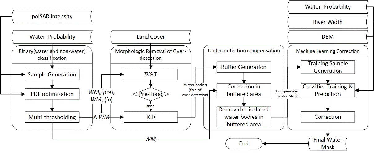
Figure 1. The RAPID Kernel Flood Delineation Algorithm.
The Kernel algorithm integrates many ancillary datasets besides the SAR data and needs a certain processing time (~ 12h after data acquisition). Therefore, the RAPID system does not process the whole data archive blindly. Instead, a triggering system based on USGS water watch and StageIV/IMERG (Figure 2) is built-in RAPID to identify potentially flooded zones on daily basis.
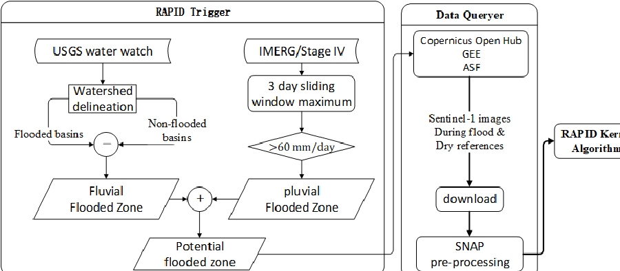
Figure 2. Structural Overview of the RAPID System.
References:
[1] Xinyi Shen, Emmanouil N. Anagnostou, George H. Allen, Robert G. Brakenridge and Albert J. Kettner (2019). “Near-Real Time Non-obstructed Inundation Mapping by Synthetic Aperture Radar” Remote Sensing of Environment, 221, 302-315. DOI: 10.1016/j.rse.2018.11.008.
[2] Xinyi Shen, Dacheng Wang, Kebiao Mao, Emmanouil Anagnostou, and Yang Hong. (2019) “Inundation Extent Mapping by Synthetic Aperture Radar: A Review”, Remote Sensing, 11, 879, DOI: 3390/rs11070879.
[3] Qing Yang, Xinyi Shen*, Emmaouil Anagnostou, Jack Eggleston, and Albert Kettner “A High-Resolution Flood Inundation Archive (2016–the Present) from Sentinel-1 SAR Imagery over CONUS”, Bulletin of the American Meteorological Society, DOI:10.1175/BAMS-D-19-0319.1
Conference:
[1] X. Shen, R. Lazin, E. Anagnostou, D. Wanik, G. Brakenridge, “Mapping the Recent US Hurricanes Triggered Flood Events in Near Real Time”, NH23E-2825, AGU Fall Meeting 2017, New Orleans.
[2] X. Shen, E. Anagnostou, Z. Zeng, A. Kettner, Y. Hong “What is missing? An operational inundation mapping framework by SAR data”, H53J-1603, AGU Fall Meeting 2017, New Orleans.
[3] X. Shen, E. Anagnostou, H. Seyyedi, “Rapid SAR-based Flood-water Depth Estimation“, AGU Fall Meeting 2018, Washington D.C.
[4] X. Shen, Q. Yang, E. Anagnostou, A. Kettner, J. Jones, G. Schumann, “A partial polarimetric decomposition-based method for delineating wetlands/inundation under vegetation”, AGU Fall Meeting 2019, San Francisco.